Fire Restrictions
Emergency Closure Info
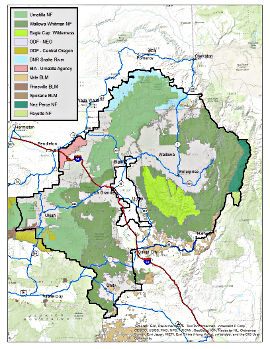
Region 06, Fire Closures Public View Map
|
 Click for Fire Restrictions Map |
Updated 10-Jun-2026 14:12:56
Fire restrictions can originate from many places. Federal agencies such as the US Forest Service, and Bureau of Land Management, can impose restrictions on the public land they manage. Individual states such Oregon and Washington can impose restrictions on state managed land. Confusion can result from the multiple agency jurisdictions, especially when adjacent lands have different restrictions depending on the administering agency. The sites listed below are only a guide. The individual should seek local information for up to date fire restriction information.
Wallowa Whitman National Forest Alerts & Notices
Umatilla National Forest
Bureau of Land Management
Oregon Department of Forestry
Washington Department of Natural Resources
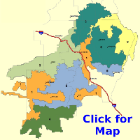
| Fire Danger Rating Area | |||
| FDRA 1 Union / Baker County Valleys Dispatch Level Yellow | FDRA 2 Canyon Grasslands Dispatch Level Green |
FDRA 3 Western Blues Dispatch Level Green | FDRA 4 John Day Valley Dispatch Level Green |
 |
 |
 |
 |
| FDRA 5 Central Blues Dispatch Level Yellow | FDRA 6 Eagle Caps Dispatch Level Green | FDRA 7 Northern Blues Dispatch Level Green | FDRA 8 Elkhorns Dispatch Level Green |
 |
 |
 |
 |
 | |||


