
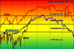
Fuels and Fire Danger
Click on Map.
Region 6 Fire Danger Areas
Local ERC Charts
Pocket Cards
Outlooks
Fire Danger/Industrial Fire Precaution Level
| Fire Danger Rating Area | |||
| FDRA 1 Union / Baker County Valleys Dispatch Level Red | FDRA 2 Canyon Grasslands Dispatch Level Yellow |
FDRA 3 Western Blues Dispatch Level Yellow | FDRA 4 John Day Valley Dispatch Level Red |
 |
 |
 |
 |
| FDRA 5 Central Blues Dispatch Level Red | FDRA 6 Eagle Caps Dispatch Level Yellow | FDRA 7 Northern Blues Dispatch Level Yellow | FDRA 8 Elkhorns Dispatch Level Yellow |
 |
 |
 |
 |
| Industrial Fire Precaution Level | |||||
| Umatilla North |
Umatilla South |
Washington DNR Snake River |
Wallowa | Whitman | Emily |
 |
 |
 |
 |
 |
 |


